 |
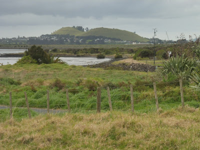
| Te Pane o Mataoho, seen from Cornwallis on the Manukau Harbour, this may well be the view seen by Māori as they traversed the Manukau by Waka. Source: Author (2017). |
 | ||
| The Maunga was one of the most important pa sites in South Auckland, casting a wide influence over the area due to its imposing size as one of Aucklands largest scoria cones. View here from Oruarangi awa at Ihumātao. Source: Author (2017). |
 |
| From the summit of the maunga, amongst the scoria outcrops, inhabitants of the pa would have had a panoramic view over the surrounding flats and water bodies, with Rangitoto visible on the horizon here. Source: Author (2017). |
 |
| 1940 Aerial view of the maunga and Mangere Lagoon explosion crater, open to the Manukau before it was closed off for the Manukau Sewage Scheme. Lava flows extend to the shore of the Mangere Inlet, with surrounding land predominantly small farms and market gardens, Source: LINZ. Retrieved from: www.retrolens.nz (2017). |
 |
| 1988 aerial view of Te Pane o Mataoho. The Mangere Lagoon has become part of the sewage settling ponds, and the harbour between the foreshore and Puketutu Island has been closed to the natural flow of the tides by bunds, forming large sewage settling ponds. Very little undeveloped land remains around the Maunga, except for the empty area facing Puketutu Island, that will become Ambury Farm Park. Source: LINZ. Retrieved from: www.retrolens.nz (2017). |
 |
| In 2017 the maunga stands out as a green space surrounded on all sides by urban development. After the largest environmental restoration project in New Zealand commencing in early 2000s, the sewage settling ponds have been decomissioned, and the Mangere Lagoon has been opened to tidal flow again, with a small artificial island in the centre replacing the original small cone that was destroyed. Ambury Farm Park is the other green space, with shell banks offshore providing roosting space for shorebirds. Source: LINZ. Retrieved from: http://data.nzpam.govt.nz/permitwebmaps?commodity=minerals |
 |
| Above and below: The head of Mataoho watches over the whenua, no matter what the time of day or weather, one can always feel it's presence. Source: Author (2017). |
 | |
| Discover the many faces of Te Pane o Mataoho click here! |


love it ilmars!
ReplyDeleteGreat blog. All posts have something to learn. Your work is very good and i appreciate you and hopping for some more informative posts. Fish Mounts
ReplyDelete