This post was originally published in September 2019. On 9th December 2019 the volcano explosively erupted while 47 people were on the Island. This blog post is dedicated to the memory of the 21 victims passed away as of 29 January 2020. I also acknowledge rescue and disaster recovery workers worldwide, and the work of volcanologists worldwide.
 |
| Te
Puia o Whakaari/White Island, view from eastern Bay of Plenty looking into main crater with steam fumeroles visible just above sea-level. Source: Author (2017). |
While conditions in the Whakatāne Harbour were relatively calm, the hour and a half boat trip thanks to White Island Tours saw some fairly green passengers by the end of the trip due to the rolling swell encountered as soon as the boat reached deeper water. Whakaari is in fact a large volcanic complex, approximately 16 x 18 km, the majority of which is underwater, with only the peak visible above water as the island we can see. The island volcano is part of a belt of volcanism that starts at Ohakune (part of a region commonly referred to as the Taupō Volcanic Zone (TVZ)) and continues offshore to Whakaari.
If you would like to know more about the Taupō Volcanic Zone, and the geological forces that have shaped the Eastern Bay follow this link to a previous post "Ōpōtiki, the shifting and fiery land around us. A thrilling story of volcanism and tectonics...."
It may surprise you that approximately 70% of the Earth’s volcanic activity occurs underwater, and Whakaari is part of a chain of underwater volcanoes extending as far as Tonga called the Kermadec Arc. A distant perspective may give us a sense of the island as relatively small, but it is a significant landmass approximately 2 x 3km. Setting foot on the island gives one an entirely new perspective of this surreal and raw landscape, constantly changing and subject to the influences of volcanic activity, landslides and earthquakes, and influences of hydrothermal gases and liquids.
 |
| A group of people viewed from the distance gives one a sense of the scale of this volcanic landscape, shaped by huge mounds of ash and volcanic debris, landslide scars, and hydrothermal features. Source: Author (2019). |
 |
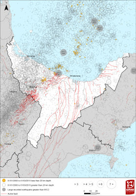
| This detail of seafloor features surrounding Whakaari shows that the island above water is just one part of a significant complex of volcanic features and underwater canyons and sea-mounts. Source: NIWA (2019). |
 |
| Diagram showing the majority of the White Island volcanic cone under water, and magma chamber and conduit during one of several types of eruptive phase typical of White Island. Source: Adapted from Cole et al. (2000). Magma origin and evolution of White Island (Whakaari) Volcano, Bay of Plenty, New Zealand. Journal of Petrology, 41(6), 867-895. |
The Māori name Te Puia o Whakaari means “The Dramatic Volcano” or “that which can be made visible” and is explained in two Māori legends. One tells of Maui fishing the North Island out of the ocean, accidentally stepping on the land and some of the fire burning on it. Where he shook this off his foot into the sea this became Whakaari. Another legend tells of the arrival of Chief Ngatoro-i-rangi bringing fire from Hawaiiki. Leaving his sisters at Whakaari, he voyaged to Maketu and onwards to Tongariro. Finding it so cold at Tongariro he called on his sisters to send fire. Volcanic and thermal activity between Whakaari and Tongariro marks the route of the underground journey taken by spirits bearing fire. The volcano, most of which is underwater with the main crater only 30m above sea-level, has been continually active since human settlement of New Zealand, with one of the most the most active periods between 1976-1982. Presently the volcano is at an alert level of 1, meaning minor volcanic unrest.
 |
| Report on sequence of eruptions occurring between 1976 and 1982 when ash clouds several kilometres were formed and lava bombs up to a metre in diameter were ejected. Also significant changes to craters and vents took place. Source: GNS.cri.nz |
The name White Island was given by Captain Cook who only ever saw the island from a distance. The most commonly cited theory was it was referring to the ever-present white steam-plume. However, according to some researchers Cook noted the similarity of the rocks around the Island to the Needle Rocks, off the Isle of Wight, and marked our "White Island" on a chart prepared for Joseph Banks as "The Isle of Wight".
The island passed into the hands of European officers in the mid-19th century, allegedly for two hogsheads of rum. From 1885 onwards the island was the site of commercial sulfur mining, which continued till 1933 despite several miners being killed by a landslide from the crater wall in 1914. Understandably such a unique, dynamic, and relatively accessible volcanic feature has long been of interest, both for scientific interest and tourism , as can be seen in this photo of an early 20th century field trip to White Island.

The history of sulphur mining and the associated loss of life and injuries on the island are well documented, and I have added here some links that tell the grim story of the brutal conditions, efforts to make mining profitable, and the loss of lives.
"The island gives its few visitors an almost fearful sense of loneliness —
a place where time could be cut short. And no wonder, for everyone who
does come here is all too well aware of its grim history ... of how the
1911 company’s efforts to work the island’s sulphur deposits came to a
disastrous end"
– From the narration, on the 11 men killed on the island in 1914
The island remains in private ownership, and is now classified as a scenic reserve. Monitoring of the volcano measures ground deformation, while regular monitoring also measures composition of volcanic gases and hydrothermal fluids. Landing on the island is limited to several certified tour companies, which provides a unique opportunity to walk in the active crater of a volcano, and experience the surreal landscape consisting of ash, freshly erupted rock and lava, and colourful hydrothermally altered minerals.
 |
| Approaching the island an Australasian Gannet colony is visible, making a home on a mat of native ice plant. Source: Author (2019). The Island is also home to a colony of grey-faced petrel, also known as ōi, kuia, or the northern muttonbird. You can read more about this bird at this earlier post. Ōi, our burrowing seabird neighbours, the northern muttonbird by Paul Cumming. |
 |
| New Zealand fur-seals lounge in the sun on the rocks around the island. The water's support rich web of fish, sea-birds, and marine mammals. Source: Author (2019). |
 |
| Remains of the sulphur mining industry provide a stark reminder of the difficult conditions here, with metal rapidly corroding in the acidic and salt-laden atmosphere. Source: Author (2016). |
 |
| Above and below. A surreal and stark landscape is formed by stratified layers of ash, land-slip scars, and lava outcrops, all showing signs of hydrothermal alteration and precipitation of minerals from liquids and gasses. Source: Author (2019). |

 |
| Above and below. Silica-rich minerals are a common sight, precipitated from mineral-rich hydrothermal fluids and volcanic gases. Source: Author (2019). |

 |
| Above and below. Sulphorous minerals provide a bright yellow splash of colour in this otherwise stark landscape coloured grey by andesitic ash and unweathered rocks forming the landscape. Source: Author (2019). |
 |
 |
| Above and below. Crystalline sulphur precipitated from volcanic gas fumeroles form distinctive, surreal, and beautiful "chimneys". Source: Author (2019). |

 |
| A lava bomb deposited in ash shows signs of recent deposition, with a small impact depression around the lava still visible in the ash. Source: Author (2019). |
 |
| A "breadcrust"lava bomb shows a distinctive crust, caused by very rapid cooling of lava as it travels through the cold air. Source: Author (2019). |
 |
| A lava bomb demonstrates the rapid rate of mineralisation and crystalisation on surfaces, with the andesitic lava bomb barely visible beneath a thick crust of volcanic minerals. Source: Author (2019). |
 |
| The main crater undergoes regular changes through eruptions, crater wall collapse, and movement of multiple vents and fumeroles. The extremely acidic hot lake also undergoes regular changes in level. Source: Author (2019). |
 |
| Several cameras monitor activity in real time, and a 10 minute snapshot can be seen at the GeoNet website. Monitoring also includes seismometers (earthquake activity), UV spectrometers (SO2 emission rate), and GNSS (ground deformation). Visit the GeoNet monitoring website here. |
 |
| A retort lies abandoned and corroding, one of several remains of the mining endeavour that attempted to extract profitable sulphur from this harsh and unforgiving landscape. Crushed rock was heated in the retort to extract sulphur, with a worker being killed in the very early days of mining when a large retort exploded. Source: Author (2019). |
 |
| As one leaves the island the remains of the sulphur works provide a stark reminder of the precariousness of human life and endeavours on an active volcano. Source: Author (2019). |
 |
| Stratified layers of volcanic layers exposed in crumbling and unstable cliffs leave a lasting impression of the ceaseless volcanic activity on the island and a dynamic landscape that tells a story of land being formed and destroyed before our eyes in a geological instant. Source: Author (2019). |


