 |
| Aerial view looking into steep-sided secondary eruption crater on Te Pane o Mataoho. The small rectangular depressions are rua kūmara (kūmara storage pits). Beyond the crater can clearly be seen quarrying operations extracting scoria from the base of the cone. Source: Whites Aviation (1960). Retrieved from National Library of NZ (2018) |
Te Pane o Mataoho (Mangere Mountain) is one of the
largest and most distinctive volcanic scoria cones in the Auckland Volcanic
Field. Its familiar profile can be seen from across the Manukau, and is the dominant landmark in the South Auckland suburb of Mangere Bridge, reflecting the weather
and time of day, and displaying its many faces as one moves through the landscape shaped by the eruption that gave birth to Te Pane o Mataoho - the head of Mataoho
In addition, the maunga is home to the Mangere Mountain Education Centre, a unique living museum, learning centre, and repositiry for the stories and taonga of the maunga and its people. The second part of this post will focus more on the human history of the area, and the unique role played by the Education Centre in bringing this history alive and
carrying it into the future. However, thousands of years before people lived
here there is another story that the whenua of today tells us, and that is the
story of how this imposing scoria cone and its surrounding lava flows erupted and shaped the familiar landscape we see today.
Mangere mountain is one of approximately 53 volcanic centres within the Auckland Volcanic Field (AVF), a basaltic intra-plate volcanic field that lies beneath the city of Auckland and has given it one of its most distinctive features, it's numerous volcanic cones and other vocanic landforms.. This type of volcanism occurs when a mantle hotspot beneath the crust feeds magma through weak spots in the crust, as it rides over the stationary hotspot. One of the most distinctive
examples of this type of system is the Hawaiian islands, formed by a chain of
volcanoes marking where the magma has erupted through the moving crust. In the
satellite view below of Hawaii, the chain of undersea volcanoes behind the Big Island of Hawaii show the direction of movement of the Pacific plate over the
stationary mantle hotspot. Volcanic activity continues today on the Big Island
of Hawaii, however in time as the Pacific Plate relentlessly moves on,
underwater volcanic activity has commenced south of Hawaii forming the
submerged but growing volcano of Lo’ihi.
 |
| The Hawaiian Islands sitting in the Pacific Ocean. A mantle hotspot below the seafloor formed by the Pacific Plate has formed the chain of islands. Blue arrows show direction of movement of plate while hotspot has stayed stationary, relative to plate. The kink in the seamount chain shows where the plate movement changed direction. Source: Modified from Google Earth (2018). |
In the case of the mantle hotspot underlying the Auckland
Volcanic Field, it has also shown to have been underlying three other discrete volcanic fields as shown in the picture below. In the oldest field, Okete, volcanic features are heavily eroded, and the fields become progressively younger towards the north, suggesting southwards movement of the crustal plate. Interestingly this does not equate with evidence that the plate is actually moving northwards, therefore it seems in this case the actual mantle plume may not be stationary.
 |
The four volcanic fields seen here mark progress of the crustal plate as it has moved relative to a mantle hotspot. Volcanic features in the oldest field, Okete, are heavily eroded, while features in the AVF are relatively fresh, the most recent eruption being Rangitoto with parts of its lava fields still not colonized by soil and vegetation. Source: Nemeth et al. (2012). Monogenetic volcanism of the South Auckland and Auckland Volcanic Fields. |
 |
| Auckland Volcanic Field (intra-plate hot-spot volcanism) in relation to the Taupo Volcanic Zone (inter-plate subduction volcanism). Source: Modified from Google Earth (2018). |
Hot-spot volcanism is a very different system to subduction generated volcanism, which is behind our dynamic and geothermally active Taupo Volcanic Zone shown on the above map. Read about the shifting and fiery land of the Taupo Volcanic Zone here, if you would like to find out more about subduction volcanism and how the geological forces underlying this area differ from those behind the Auckland Volcanic Field.
Volcanic activity in the AVF commenced approximately 200,000 years ago, and has continued to the present, with a more vigorous phase of activity commencing approx 60,000 years ago and continuing to the present with the eruption of Rangitoto approx, 600 years ago witnessed by human inhabitants of Motutapu. This sequence suggests that not only is the AVF active, but also still in its infancy.
 |
| Human footprint in Rangitoto ash found on Motutapu. When found the footprint was covered in ash erupted from Rangitoto. Source: R. Nichol. Retrieved from: teara.govt.nz (2018) |
The most recent radiometric dating of Te Pane o Mataoho, using isotopes of argon, places the age of eruption at approximately 70,000 years ago. By studying nearby deposits from the Mangere Lagoon eruption crater that have been covered by lava from the nearby maunga we can confidently say the lagoon was the site of the first eruption. We also know that there was no time for soil to develop on top of the first deposit, so it is likely the two eruptions were fairly close together.
 |
| 1931 View from Mangere Mountain, across Mangere Lagoon looking towards Maungataketake. The Lagoon is open to the harbour, with Wallace Road running across the foreground of photograph. Source: J. Richardson/Auckland Libraries. Retrieved from: Auckland Libraries (2018). |
While the scoria cone is the most dominating feature of this area, it was formed by several distinct eruptive processes, common to many of the volcanoes of Auckland, with the landscape around us telling the story of these violent events. The eruptive phases can be broadly divided into three distinct processes
Phreatomagmatic
Approximately 70% of Aucklands volcanoes started with violent and explosive eruptions caused by hot rising magma interacting with ground or surface water. This type of eruption is called a phreatomagmatic eruption, and occurs when hot magma causes water to flash to super-heated steam, and rapid cooling of lava causes it to shatter into fragments. In many cases the eruption may cause a horizontally moving cloud of wet ash, gasses, and lava fragments. In time this material builds up a ring around the crater called a tuff-ring. Below is an example of a volcanic eruption taking place in sea-water, where a tuff-ring is clearly visible building up above sea-level. |
| Phreatomagmatic eruption in the sea of Japan, showing explosive eruption cloud formed by hot magma interacting with seawater. Also clear is the tuff-ring rising above the sea-surface. In time the tuff ring may separate the seawater from magma, meaning the eruption will transition to a dry magmatic eruption forming a volcanic island above sea-level. Retrieved from: http://plate-tectonic.narod.ru/japan32photoalbum.html (2018). |
In the case of Maungataketake at Ihumātao, eruption commenced with a phreatomagmatic eruption that then transitioned into a dry magmatic eruption. While the scoria cone and tuff-ring formed in the later parts of the eruption has been removed by quarrying, we can see a spectacular example of the results of a horizontal surge exposed in the eroded cliffs on the nearby Manukau Harbour foreshore.
 |
| Layers of ash and lava fragments laid down by successive eruption events. Some layers would be deposited by air-fall while others would be the result of horizontal surge clouds. The eruption cloud also contains water, which cements the components into a semi-hard deposit called tuff. At the bottom of outcrop is a tree buried and preserved in ash. As erosion has exposed the tree to air it will now rot away, leaving a round "mould". The light coloured rock at the top of the outcrop is a piece of sandstone ejected as the magma erupted through it. Source: Author (2016). |
 |
| Detail of typical layered tuff deposits from Maungataketake volcano. Dark grey layers consist of fragmented lava while lighter layers are composed mainly of ash. Each layer represents a pulse of volcanic activity that may be hours, days, or weeks apart. Source: Author (2016). |
 |
| Cross section through typical phreatomagmatic eruption, with magma interacting with groundwater to form ash and steam cloud, and layers of tuff building up around crater. If the eruption ceases at this point the crater may become infilled with water and sediment, forming a maar lake. Source: Modified from Augustin-Flores et al. (2014). Phreatomagmatic eruptions through unconsolidated coastal plain sequences, Maungataketake, Auckland Volcanic Field (New Zealand). Journal of Volcanology and Geothermal Research. |
In some cases of these types of eruption, magma supply may run out at this stage, meaning the eruption ceases and a hollow crater is left in the ground that may also be surrounded by a tuff-ring. In time these craters (called maar craters) will fill with water and sediments, either forming lakes or swampy lagoons. The Mangere Lagoon is an example of a maar, though it did have a small scoria cone in the centre and was open to the Manukau Harbour. Also formed by an explosion crater is the Pukaki Lagoon, originally open to the Pukaki Creek, but subsequently damned and turned into a speedway. Since then the land has returned to control of the local iwi and the council as a public reserve, and the lagoon remains as one of Auckland's most pristine volcanic features.
 |
| 1925 view across Pukaki Lagoon, with extensive mangroves growing in shallow sea water from the Manukau via Pukaki Creek. In 1929 the creek was damned in order to enable drying out of the lagoon, and the lagoon subsequently turned into a speedway track. Source: J. Richardson/ Auckland Libraries. Retrieved from Auckland Libraries (2018). |
 | |
View across Pukaki Lagoon explosion crater with Crater Hill volcano
in the background. The small lake has formed in the explosion crater inside
a tuff ring. The stream running towards the lagoon is Pukaki Creek, which
still remains disconnected from the lagoon itself by an earth dam.
Source: Jamieson (2009). Pukaki Tapu o Poutekeka: Vegetation history &
potential for ecological restoration. Manukau City Council.
|
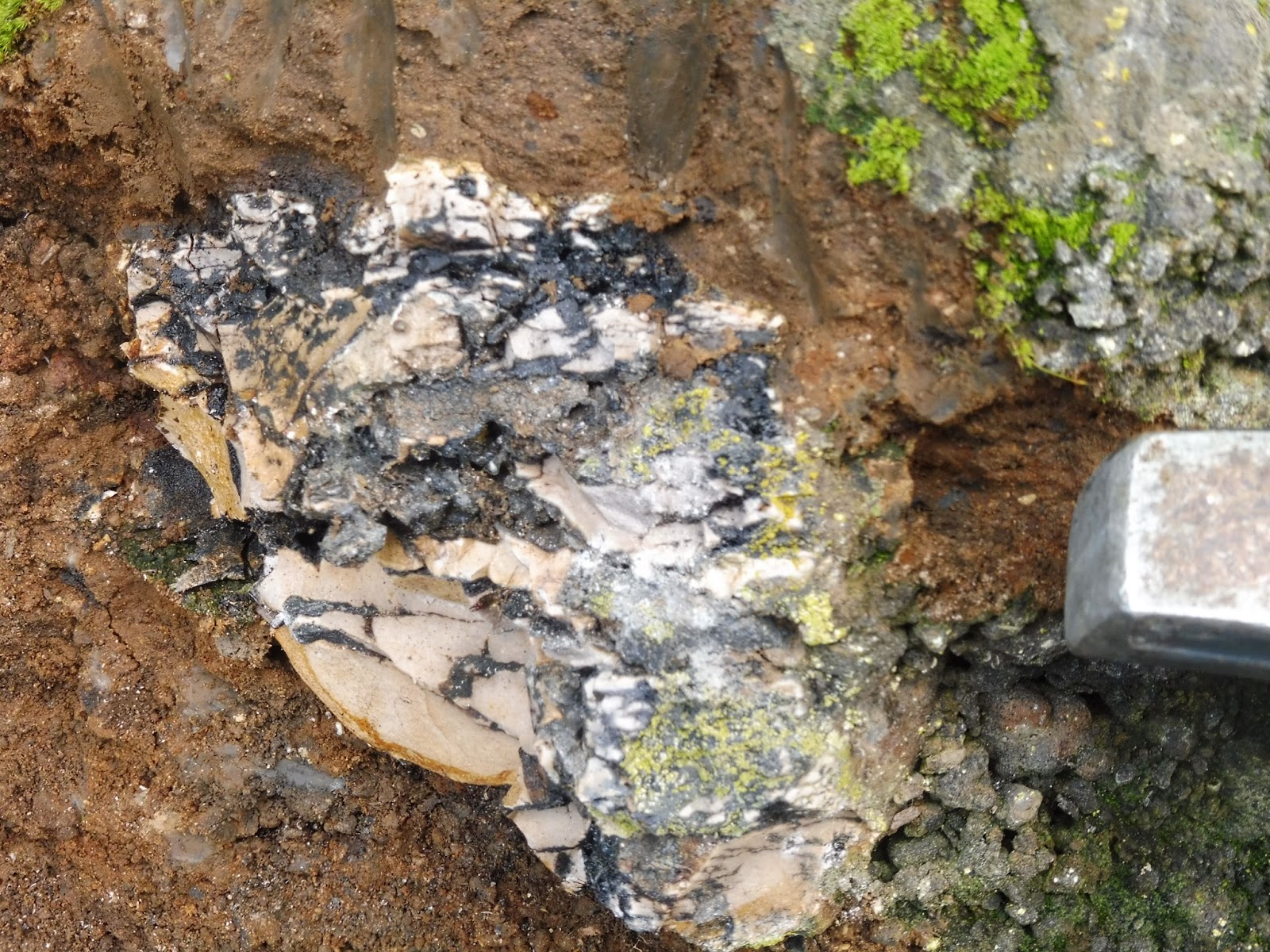
It is uncertain if the formation of the scoria cone was preceded by a phreatomagmatic eruption (the Mangere Lagoon explosion crater is considered a separate event), as any evidence has likely been covered by the later dry magmatic phase of the eruption forming the scoria cones and lava flows. The photographs below show an outcrop on the lower slopes of the maunga, which may provide evidence of interactions between magma and water, with possibly a tuff deposit alongside scoria and lava in the same outcrop. Further physical and chemical analysis of samples from this outcrop would confirm the presence of external water during the eruptive phase.
 |
| Outcrop of Te Pane o Mataoho at base of cone. The location of this outcrop suggests these could be products of an early eruptive phase of the maunga interacting with water. Also present in the same outcrop is scoria and lava bombs, produced during the dry phase of the eruption. Source: Author (2016). |
 |
| Same outcrop as above, approx. 2 metres to the left. Hammer is sitting underneath solid lava flow underlain by scoria. Lava flow would have occurred as last phase of eruption, intruding through base of already formed scoria cone. Source: Author (2016). |
 |
| Above and below: Lava bomb from same outcrop, consisting of fine grained sedimentary sandstone fragments bonded together by glassy lava. The sandstone comes from the sedimentary layers the lava erupts through, early in the eruption sequence, when it may be erupted to the surface along with volcanic products. Source: Author (2016). |

Fire fountaining
As a phreatomagmatic eruption proceeds, and should the supply of magma continue, water may become excluded from contact with magma and the eruption transitions to a purely magmatic "dry" eruption. This phase of the eruption is a process called fire-fountaining as gas dissolved in the magma is released, propelling magma many metres into the air in a fountain of lava and gasses. Because basaltic magma is relatively free flowing it is able to form fountains up to hundreds of metres height. |
| Lava fountain of the Pu`u `O`o cinder and spatter cone (scoria cone) on Kilauea Volcano, Hawai`i. Over time the fire fountain builds up a cone of scoria and loosely welded basalt. Source: J. Griggs/USGS (1983). |
 |
| Paricutin volcano in Mexico, erupting at night. As lava erupts from the cone it is red-hot, but on contact with the air it quickly cools and forms scoria that builds a cone as the eruption proceeds. Scoria cones may also contain larger conglomerations of welded basalt. Source: C. Fries/ USGS (1948). |
Scoria is a basaltic lava that cools so quickly bubbles formed by the releasing gasses are preserved in the solid. Bubbles can range in size from barely visible to millimetres across, and in some cases very light scoria may consist of more air bubbles than solid lava. Scoria may also vary in colour, weight, and density, depending on variations in chemistry and variations in eruption temperature. Lava may also erupt as bombs, which cool on contact with the air, but may still be plastic enough to change shape as they fly through the air and hit the ground.
 |
| Scanning electron microscope images of scoria lappilli (small volcanic fragments from 2mm - 64mm) showing variations that provide clues to conditions at the time of eruption. Sizes above range from 1-3mm and are from (A) Otuataua; (B) Browns Island; & (C) Rangitoto. Source: Keresszturi & Nemeth (2016). Sedimentology, eruptive mechanism and facies architecture of basaltic scoria cones from the Auckland Volcanic Field (New Zealand). Journal of Volcanology and Geothermal Research. |
 |
| Outcrop of loosely welded scoria erutped from Otuataua, still retaining enough heat after eruption for the scoria to weld. The pink/red colour is due to iron in the scoria oxidising in the elements (rusting). Source: Author (2016). |
 |
| Loose weathered scoria erupted from Otuataua. Different colours reflect variations in chemistry of lava and rates of weathering. Source: Author (2016). |
 |
| Fragment of scoria from Te Pane o Mataoho, showing dark and glassy face where it has not been exposed to weathering, On close examination scoria contains fragments of brown sedimentary rock, suggesting this was ejected during an early phase of the eruption. Source: Author (2016). |
 |
| "Ribbon" lava bomb from Te Pane o Mataoho. The ribbon shape of the bomb forms as hot and still plastic lava flies through the air. By the time the lava hits the ground it is cold enough to preserve the shape. Source: Author (2016). |
 |
| "Cow pat" lava bomb from Te Pane o Mataoho, formed when still hot lava hits the ground, and is plastic enough to form a flattened shape that resembles a cowpat. Source: Author (2016). |
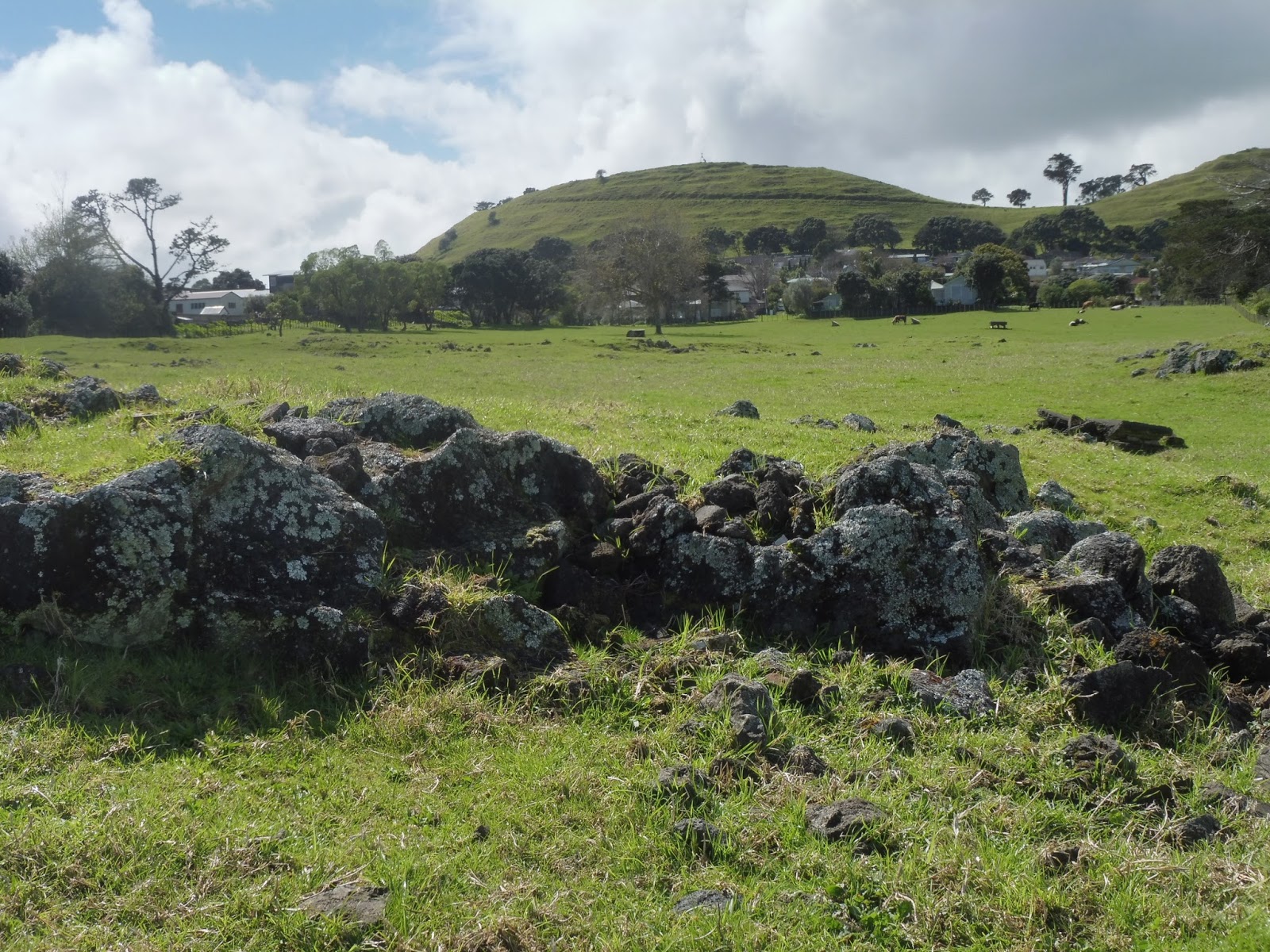
As the eruption proceeds scoria falls around the perimeter of the eruption centre, and in time builds up a cone with a crater at the top. Over time the loosely consolidated and in places welded scoria may fall down the sides of the growing cone, meaning the slopes of the cone generally won't grow steeper than approximately 45 degrees angle and the base of the cone grows outwards.The cone may also contain larger conglomerations of welded basalt and bombs, which provide strength to the structure. Te Pane o Mataoho is distinctive for having two craters and within the largest crater is a smaller shallow crater. Multiple craters may form through a process called vent migration, whereby the preferential path for the magma to take over time may change, in turn changing the point of eruption on the surface. Another example of this could be seen at Waitomokia at Ihumātao with its multiple scoria cones.
 |
| View across Te Pane o Mataoho showing two separate eruption craters in the cone, and the Mangere Lagoon explosion crater in the background. At the bottom of the cone is a small scoria mound in the process of being removed by quarrying. Rising from the floor of the largest crater can be seen the tholoid, a plug formed by cooling magma as the eruption loses energy and the last of the magma to reach the surface forms a dome. Source: Whites Aviation (I951). Retrieved from National Library of NZ (2018). |
 |
| 1940 aerial view of the scoria cone and two explosion craters. The tholoid can be seen slightly off-centre in the largest crater. Rectangular depressions around the rim of the smallest crater are kumara storage pits. Source: Source: LINZ. Retrieved from: www.retrolens.nz (2017). |
Lava flows
As a basaltic eruption continues to build a scoria cone through ejection of gas and lava, over time gas pressure in the conduit may decrease and magma is erupted as horizontally moving liquid lava flows. Lava flows may may erupt by intruding through the poorly consolidated scoria cone, or in some cases from the crater by breaching the walls of the crater rim. While lava may not be propelled by gas pressure like in a fire fountain, lava may contain dissolved gases that form bubbles as the magma rises to the surface and pressure decreases.
 |
| Above and below: Lava often contains dissolved gasses that form bubbles preserved in the lava as it cools. Bubbles may vary in size and density, reflecting changing dynamic conditions within the same flow. Source: Author (2015). |


Basaltic magma forms two types of lava flow, both given Hawaiin names Pahoehoe and A'a'. The type of lava flow formed by erupting magma mainly depends on temperature at eruption and rate of cooling. Pahoehoe is formed by hotter lava, erupted at a lower volume that rapidly cools. As the lava flows forward the skin formed by rapid cooling bunches up behind the flow front, giving the surface it's ropey appearance. Because basaltic magma is not viscous (relatively liquid compared to other viscous types of lava), rapidly moving pahoehoe flows can cover a large area from their point of eruption.
The scoria cone of Te Pane o Mataoho is surrounded by extensive lava flows underlying the relatively flat and fertile land surrounding the cone. Ash erupted by the maunga has formed a layer of fertile mineral-rich and well draining soil, while drainage is facilitated by cracks, bubbles, and joints in the underlying lava. Much of the water draining through the lava finds it's way to the foreshore where it provided important fresh-water springs to the early inhabitants of the area. Unfortunately most of these springs have been destroyed by industrial development in the area.
The distinctive ropey surface of pahoehoe lava flows can be seen at lava outcrops on the foreshore at Kiwi Esplanade in Mangere Bridge. While these outcrops may be considered already some distance from the maunga, they are in fact much more significant than they first appear. At the time of eruption the Mangere Inlet was a river bed, and drilling has shown that the lava flowed across the river bed as far as White Bluff at Hillsborough.
 |
| Above and below: Pahoehoe lava flow at Kiwi Esplanade, Mangere Bridge. The bunched up surface of the flow is formed as the surface rapidly cools, while the still liquid lava moves forward beneath the surface, giving the flow its ropey appearance. Source: Author (2015). |

 |
| Cross section across Mangere Inlet taken from bore hole data. Basalt lava flow (covered by marine mud) is shown extending from the Mangere foreshore (left) to White Bluff at Hillsborough (right). Source: E.J. Searle (1959). The volcanoes of Ihumatao and Mangere, Auckland. New Zealand Journal of Geology and Geophysics. |
The second type of lava flow formed by basaltic magma is called a'a' (another Hawaiin word). The short video above shows how the two types of lava flows form, as well as explaining lava tubes and caves. Lava caves in flows from Mangere Mountain can be found at Ambury Farm, along with outcrops of lava flows visible through the grass cover and extending onto the foreshore. Lava caves were common throughout basalt lava flows of Auckland, and several significant caves are also associated with Pukeiti and Otuataua at Ihumātao.
A'a' lava flows form when more significant amounts of lava are erupted at a cooler temperature, meaning it is slower moving and forms a blocky flow with a crust formed of sharp crusty lava. Due to the effect of ongoing cooling pahoehoe lava can turn into a'a', but never the other way around. Most a'a' lava flows from Te Pane o Mataoho can be hard to see in outcrop because they have been covered in soil and grass, or built over. However occasionally a glimpse can be seen of thick blocky lava that would have erupted from the maunga, and slowly flowed to where it has come to rest. Most of the gently sloping areas surrounding the maunga are underlain by lava flows that may be many metres thick in places, and as anyone who has had one of these lava flows get in the way of excavation will know, they form a very dense and hard basalt.
 |
| A'a' lava flow outcrops beside footpath in Mangere Bridge. These flows may be significantly thicker, as many streets follow the natural topography created by the surface of the flows, with most of the lava flow still underground. Source: Author (2017). |
 |
| Basaltic lava exposed by quarrying at base of Te Pane o Mataoho scoria cone. Remnants of basalt lava can be found in many quarries because the desired product was scoria and basalt was considered uneconomic to remove. Source: Author (2017). |
 |
| Above and Below: Compared to fast-moving pahoehoe lava this a'a' lava in Hawaii moves relatively slowly, and can be safely outpaced. However once it is moving the force of it can be relentless and extremely destructive. Source: J. Briggs/USGS (1983). |


The tholoid
Te Pane o Mataoho has one particular feature that makes it unique amongst volcanoes of Auckland, and that is the dome shaped mound in the largest crater, called a tholoid. While this may have the appearance of a small scoria cone within the crater, it is in fact a lava dome, extruded towards the end of the eruptive sequence. At this stage energy driving the magma to the surface would have been decreasing, just providing enough energy to extrude this cooling plug of lava that got no further from the point of eruption before cooling and forming this dome. The photos below show the tholoid which is actually offset from the centre of the crater, and adjacent to a smaller shallow eruption crater.
 |
| Above and Below: Dome formed by the last of the magma to be erupted during the dying phase of eruption. Low energy and low volume of magma means the dome has time to cool, forming a plug preventing further eruption. In photo below can be seen smaller shallow eruption crater adjacent to the tholoid, and lava bombs littering the ground. Source: Author (2017). |

I hope next time you look at Te Pane o Mataoho this geological story put together using clues we find in the maunga and its surrounding landscape, will give you a vision of what you may have seen had you been witnessing the eruption, or what we may expect the next time there is an eruption in the Auckland Volcanic Field, which there undoubtedly will be. In part two of this story I will be exploring the human history of the Maunga. If you would like to keep up to date with new posts please subscribe using the form at the top right of this page
 | |
| This scoria cone and surrounding lava flows in Saudi Arabia provides an impression of how the landscape around Te Pane o Mataoho would have appeared in the time period following the eruption, before weathering processes in the warm humid climate of Auckland rapidly formed soil from volcanic products, leading to the more familiar site we see today pictured below. Source: Nemeth et al. (2017). Geoheritage values of a mature monogenetic volcanic field in intra-continental settings: Harrat Khaybar, Kingdom of Saudi Arabia.Geoheritage. |
 |
| 70 000 years after a bare scoria cone sat surrounded by bare lifeless lava flows, ash and scoria has formed rich fertile soil mantling the lava flows, encouraging native scrub and coastal forest, which in time made way for the people that came to live here and build a society based on cultivating this rich resource. Source: Author (2017). |
Click here for part 2 of The Story of Te Pane o Mataoho and her people.
| Experience the story of Te Pane o Matoho up close. Click here! |


No comments:
Post a Comment