Click here for part 1, read on for part 2 of Ōpōtiki, the shifting and fiery landscape around us.....
| Damage caused by magnitude 6.5 earthquake at Edgecumbe, 1987. Damage was so extensive because the earthquake occurred at a very shallow depth, causing damage in Matata, Thornton, and Kawerau. Source: Archives New Zealand (2015). https://www.flickr.com/photos/archivesnz/16552659081/in/photostream/ |
Last week was
quite an introduction to the shifting and unstable landscape we inhabit, when a
series of earthquakes originating offshore in the vicinity of Wharaaki White
Island were felt across the Eastern Bay of Plenty. In part 1 of this post I explored the volcanic events and processes that have shaped this
region and will continue to into the future. In this post I would like to explore the underlying structural process of plate tectonics that reminds us of its
presence with regular shakes concentrated around the shifting and grinding
plates that form Aotearoa.
Aotearoa sits on
the “Pacific Ring of Fire” formed by the boundary of the Pacific plate, one of
the largest tectonic plates on the globe. When first proposed, the theory that the continents were continuously moving relative to each other was originally considered near impossible, until a growing body of evidence demonstrated that the crust of the
Earth is formed from a series of plates that ride atop the semi molten mantle,
and are continuously shifting and recycled through the process of plate tectonics. A significant piece of evidence that confirmed the boundaries of the plates is the global pattern of
earthquakes and volcanoes, that can be seen to be more frequent at plate boundaries in the map below.
 |
| Global distribution of earthquake epicentres, with areas of highest activity shown to follow tectonic plate boundaries. New Zealand on the Pacific Ring of Fire sits on the right edge of the map. Source: https://commons.wikimedia.org/wiki/File%3AQuake_epicenters_1963-98.png (2017). |
 |
Tectonic plates of Earth and their boundaries with active volcanoes, with the Pacific Ring of Fire marked. New Zealand sits at the southwestern end of the Ring of Fire, where the Pacific Plate meets the Indo-Australian plate. Source: Source: http://vulcan.wr.usgs.gov/Glossary/PlateTectonics/Maps/map_plate_tectonics_world.html (2017).
|
However, our
country does not passively ride atop these plates, it is torn, twisted and
uplifted by the subduction of the Pacific Plate diving westwards beneath the
Australian plate at the Hikurangi subduction zone offshore from Eastern New
Zealand at a rate of 40-60 mm per year. At the same time, the
Pacific plate relentlessly grinds past the Australian plate at an average relative rate of 45mm
per year along the 600km long Alpine Fault of the South Island, pushing the Southern Alps up by 10mm a year. Offshore of the South Island the plate roles are reversed and the oceanic crust of the Australian
plate dives beneath the continental crust of the Pacific plate.
 |
| New Zealand in relation to plate boundaries forming southwestern end of Pacific Ring of Fire. Also visible is the Taupo Volcanic Zone in the central North Island, extending offshore into the Bay of Plenty and the Tonga-Kermadec Trench. Also shown the is the North Island fault belt, extending from Wellington to the Eastern Bay of Plenty. Source: Waikato Regional Council (2017). |
With all these
incredible structural processes shaping our country, and the Pacific plate
diving into the mantle beneath our feet, it is no wonder this part of the
country is regularly rocked by earthquakes generated at the large number of
onshore and offshore faults in the area. Improved
detection and mapping techniques have seen the number of known offshore faults increase from 14 faults acknowledged in 2000, to 166 in 2006. The series of quakes that shook our region
last week had their epicenter near Wharaaki White Island. The map below shows
the number of offshore faults in the Bay of Plenty region mapped by scientists
from NIWA, while the second map shows onshore faults in the Eastern Bay of Plenty and recorded earthquakes, onshore and offshore, between 2000 and 2015.
 |
| Offshore faults in the Bay of Plenty, as mapped by NIWA using seismic data and seafloor imaging. Onshore faults are visible in red. Source: NIWA (2006). https://www.niwa.co.nz/news/study-reveals-166-offshore-earthquake-sources-bay-plenty |
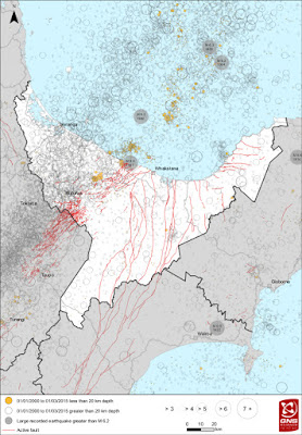 |
| Earthquake map of Bay of Plenty showing recorded earthquakes from 2000-2015. Faults are marked by red lines. Faults running south of Whakatane are part of the North Island Fault Zone extending to Wellington. The belt of smaller faults NE & SW of Rotorua are associated with the Taupo Volcanic Zone, where the crust is spreading and thinning. Source: GNS (2015) https://www.shakeout.govt.nz/bayofplenty/ |
Subduction is
the process whereby the dense oceanic crust of the Pacific plate
is forced beneath the more buoyant continental crust of the Australian plate. This
takes place to the East of the North Island at the Hikurangi subduction zone. Most
faults producing earthquakes such as those we experience in the Bay of Plenty
occur in the brittle crust of the Australian plate forming the North Island as
it accommodates the myriad stresses and strains generated by subduction. The most damaging quake of this type in the Bay of Plenty was the magnitude 6.5 Edgecumbe earthquake of 1987.
Truly
catastrophic earthquakes of magnitude 8 or greater can be generated by
sudden releases of energy from the two plates moving past each other,
generating a “megathrust” quake. Despite the frequency and intensity of
earthquakes experienced in Aotearoa, we have yet to experience the devastation
caused by ground shaking (potentially 2000 times more energy than the 2011 Christchurch earthquake) and tsunamis generated by megathrust quakes. Examples of the catastrophic and destructive power of megathrust quakes were seen in the magnitude 9.0 Great East Japan Earthquake and devastating tsunami of 2011, the magnitude 9.1 Boxing Day Earthquake and Indian Ocean tsunami of 2004, the magnitude 9.2 Great Alaska Earthquake of 1964, and the largest earthquake since modern recording began, the magnitude 9.5 Great Chilean Earthquake of 1960. The fascinating short video below describes the devastation wrought by the Great Alaska Earthquake, and how studying it in the context of the new theory of plate tectonics led to an understanding of megathrust quakes (USGS).
Shaky ground is
not the only consequence of our position torn between two plates. As the
Pacific plate sinks into the mantle pressure increases on the rocks of the
subducting plate, driving out water. This water rises and in turn reacts with
rocks of the overlying plate leading to melting and formation of magma, which
rises to the surface due to buoyancy.
And so, we come to the last piece of the puzzle forming our dynamic
volcanic landscape. The Taupo Volcanic Zone is a result of the rising magma and
heat generated by the subducting Pacific plate on its journey into the mantle
for recycling.
 |
| Diagram of the Pacific plate subducting beneath the Australian plate, with magma rising from the subduction zone forming the volcanoes of the central plateau. Source: Benjamin Moorhouse (2016). https://sciblogs.co.nz/shaken-not-stirred/2016/06/30/ruapehu-continues-fidget/ |
The Taupo
Volcanic Zone is the southern-most part of a chain of volcanoes and islands
running to Whakaari White Island, and beyond to some 90 submarine volcanoes found in the Tonga-Kermadec Arc, with the majority
of the volcanoes fully submerged.
 | |
| Seafloor depths have been used to construct this 3D model of The Monowai submarine volcanic complex, approximately 1000km northeast of New Zealand and one of the most active volcanoes in the Tonga-Kermadec Arc. A mid-2011 eruption added approximately 79m to the underwater summit. Source: GNS (2012). |
Subduction related activity produces a gassy and viscous magma with a high silica content, meaning eruptions are extremely violent and explosive, often producing steep sided cones called stratovolcanoes, built up from alternating layers of lava and ash. Typical stratovolcanoes in Aotearoa are Ngarauhoe, Taranaki, and Whakaari White Island (with the majority of its cone underwater). Other volcanic subduction zones on Pacific Ring of Fire can be found at Japan; the American Northwest and Alaska; and Central and South America.
 |
| Large ash cloud rising from crater of Ruapehu during 1995 eruption. Chateau Tongariro in foregorund. Source: Tim Whittaker, Hawkes Bay Today, Ref. VR6326. |
 |
| The Sakurajima volcanic complex in Japan, formed from three separate volcanoes, with Minami-dake pictured erupting here.Source: Kimon Berlin (2015). Flickr.com |
 |
| Fire fountaining and lava bombs seen at night erupting from Tangarahua volcano, Ecuador. Source: Alcinoe Calahorrano, US Geological Survey (1999). |
Due to the magma
generated deep underground the Taupo Volcanic Zone has one of the highest rates
of heat transference from the mantle to the crust in the world. As this heat
energy and magma rises, the crust above is measured to be spreading at
approximately 9mm per year. However, this spreading does not necessarily take
place at an even rate. The 1987 Edgecumbe Earthquake increased the distance between
Matata and Whakatane by 1.2 metres! And so, the forces working beneath our feet
continue to work together, bringing heat, steam, and volcanic gasses to the
surface of a continuously shifting, shaking, and shuddering landscape.
 |
| A sure sign that something is simmering away down below. Pohutu Geyser and Geyser Flat at Te Puia, Whakarewarewa. Source: Carl Lindberg (2002). |
If
you are interested in a more in depth exploration of the geology of the
Bay of Plenty, the GNS Qmap of Rotorua is highly recommended. Comes
with a fold-out geological map of the Bay of Plenty and a very
informative and well illustrated booklet. Maps and publications are
available on line from GNS at https://www.gns.cri.nz/Home/Products/Publications
For a great base from which to explore the volcanic plateau and it's stunning sights, check out Tāwhiri, Waiouru for comfortable and friendly acommodation.


