One of the things that kept me busy towards the end of last year was making a presentation on a subject that encompasses many of the fields that I am interested in, that can be broadly defined under the umbrella of "geoheritage". It is because of the disciplines related to this field such as archaeology, history, Earth sciences, and ecology that I find myself increasingly referring to myself as a "cultural geologist".
 |
| The author contemplates a 150,000 year story of erosion, underwater landslides, shifting continents, and massive tectonic forces shaping this spectacular outcrop at Otarawairere, Eastern Bay of Plenty. Source: Phil Pollock (2018). |
This post draws on many ideas made in a presentation to the New Zealand Geosciences Society 2018 conference. I would like to acknowledge the efforts of Bruce Hayward in organising the geoheritage symposium, and extending the invitation to present.
Financial support to attend the conference was provided by Te Papa National Services Te Paerangi, and ongoing support by the organisation for promoting this kaupapa is apprecaited. You can follow and support the organisation on their facebook page by following the link below

Finally, I would like to acknowledge my colleagues and co-authors, Chris Twemlow (Landmapping.nz), and Karoly Nemeth (Professor in Geology of Massey University).
Due to my background in Earth Sciences, I have largely been introduced to ideas related to geoheritage through the geological and Earth Sciences community. Often I am asked to explain geoheritage, and I stress the broad interpretation of the prefix "geo" as Earth, and in a more local sense the place where we stand. I am increasingly coming to see the importance of this kaupapa to the tourism, conservation, and education services. I also see an important role for the museum and heritage sector in promoting and facilitating geoheritage and geotourism ventures. While the traditional role for this sector may be viewed as collection and conservation of physical taonga, I suggest involvement by museums in collaboration with other community organisations such as libraries and local heritage societies, encourages a view of our cultural landscapes and associated geosites as a taonga in their own right.
One challenge for tourism today stems from the fact that most people’s knowledge of New Zealand prior to visiting may be limited to a series of well-publicised, extremely popular, and well utilised tourist hot-spots. We describe this as the must-see paradigm, where the tourist experience of New Zealand is limited to an itinerary based on a series of stand-alone experiences interspersed with periods of travel between destinations. This approach has seen increasing congestion at tourist hot-spots, increasing strain on infrastructure, and competing interests between local residents and visitors.
One challenge for tourism today stems from the fact that most people’s knowledge of New Zealand prior to visiting may be limited to a series of well-publicised, extremely popular, and well utilised tourist hot-spots. We describe this as the must-see paradigm, where the tourist experience of New Zealand is limited to an itinerary based on a series of stand-alone experiences interspersed with periods of travel between destinations. This approach has seen increasing congestion at tourist hot-spots, increasing strain on infrastructure, and competing interests between local residents and visitors.
 |
| Trampers await transport at the Katetahi Road end of the Tongariro Crossing. This one-day walk is considered one of the countries top tourist destinations, seeing increasing congestion and strain on infrastructure in one of New Zealand's few World Heritage Areas. Source: Kathy Ombler (2017). Retrieved from Wildernessmag.co.nz |
 |
| Beachgoers and hazard warning signs at Cathedral Cove, Coromandel. Source: www.gns.cri.co.nz (2018). |
 |
| Coromandel Peninsula is widely promoted for its white-sand beaches, set against the backdrop of a relict volcanic landscape. However, little mainstream promotion seeks to educate or enlighten regarding the geological and cultural story of this landscape. Source: http://www.coromandelfun.co.nz/ (2018). |
The term geoheritage recognises the fact that a landscape and its people have a story to tell in the ongoing history of the community which can be told through sustainable tourism and education initiatives. Geological, cultural, and ecological features with effective interpretation can be used to provide an engaging and dynamic learning experience for visitors, educators and all community members. Providing a visitor experience that integrates the natural history of the land with the cultural and human history provides a highly valued visitor experience of local, regional, and international significance. A successful example of such a venture is the Māngere Mountain Education Centre, situated on the lower slopes of Te Pane o Mataoho - Māngere Mountain. Modeled on the concept of a living museum, here one can "walk the present, discover the past".
 |
| Panel explaining the relationship between terraces visible on the side of Māngere Mountain and pre-European' Earthworks, indicating the importance of this site as a large pā situated on an extinct volcano at the centre of a network of smaller villages and gardening complexes on the ring-plain formed by lava and ash deposits from the volcano. The carved figure acknowledges the importance of this area to tangata whenua, and a landscape that physically connnects them to their ancestors. Māngere Mountain Education Centre, South Auckland. Source: Ian Lawlor (2015). |
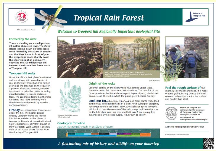 |
| Interpretation at Troopers Hill Local Nature Reserve, Bristol UK. Clear, engaging, and well laid out information integrates information on geology and environment. Source: http://www.troopers-hill.org.uk (2018). |
 |
| Interpretation panel at Ihumātao fossil forest, Māngere, South Auckland. Engaging visible material with an engaging scientifically accurate story tells the story of landscape changes due to climate change, rising sea-levels and catastrophic phreatomagamtic volcanism. Source: Author (2016). |
Here in the Eastern Bay we are blessed with a rich cultural heritage and archaeological history. When we first think of our heritage, we more than likely think of buildings or structures that have an obvious and explicit connection to our past. However, human history in this country stretching back centuries has left a rich and dynamic story written in the landscape around us.
 |
| Looking across a terraced ridge-line at Onekawa Te Mawhai Regional Park towards Whakaari - White Island. Terraces are the imprint left on our landscape by pre-European defensive earth-works. Source: Author (2018). |
 |
| Cliff-top shell midden exposed by erosion of coastal cliff-top at Waiotahe, Eastern bay of Plenty. The round group of stones visible towards the top of the shells are hangi stones (a type of oven using heated and buried rocks). This demonstrates the desirability of these locations due to the nearby marine resources, and the easily defendable cliff-top terraces. Source: Author (2017). |
 |
| Illustration showing Māori defensive earthworks and timber pallisades. Interpretation panel at Tauwhare Pā Scenic Reserve, Ōhope, Eastern Bay of Plenty. Source: Author (2018). |
The rolling hills, ridges, and natural terraces of the Eastern Bay made ideal pā sites, while valleys were home to extensive floodplains and wetlands. Rivers and smaller streams provided abundant resources as well as an extensive transport network. This was especially the case in the lands surrounding Ōhiwa Harbour, one of the most densely populated areas of the country prior to European settlement. The Eastern Bay was a highly desirable area to settle, no doubt for many of the same reasons people continue to be attracted to the area today.
 |
| Distribution of pā sites in the Bay of Plenty. High density of sites can be seen in the Tauranga region and between Whakatāne and Ōpōtiki. Source: Archaeology of the Bay of Plenty, by Garry Law, Published by the Department of Conservation (2008). |
While this may be common knowledge amongst tangata whenua, it was not until the mid 20th century that the extent of pre-European population and settlement became apparent to archaeological researchers and historians. In an early site survey by local historian and farmer David White, 200 pā sites were estimated to be present in an area from approximately 12 miles east to 12 miles west of Ōpōtiki. Since then work has continued researching, mapping, and excavating archaeological sites, confirming the extensive and complex networks of whanau and hapu that resided in this area. As technology and methods for research and surveying continually improve, we find there is still a wealth of knowledge and history to be gained from exploration of our whenua.
Unfortunately, throughout New Zealand culturally significant sites have suffered many ravages, despite protection through legislation, and the Bay of Plenty is no different. Quarrying has destroyed maunga and pā sites, roads and tracks have beeen driven through and over the top of archaeological sites and urupa, and agricultural development has all but obscured the rich layers of history preserved within our whenua. In addition, our archaeological heritage, which to a large degree is represented by sites and landscapes of significance to tangata whenua, is poorly protected protected by legislation through the Heritage New Zealand Pouhere Taonga Act (HNZPT) 2014.
Often the only Archaeological record we are left with of significant sites is through a process colloquially referred to as "rescue archaeology". Due to requirements of the HNZPT and the Resource Management Act, permission to modify or destroy a site or feature may be granted if an archaeologist is present, and a record is kept of any findings. This process particularly favours private land-owners and developers, whose primary interest is the tangible returns form economic development, rather than the intangible gains of cultural preservation. This is reflected in comments below from the recently published article "The Mounting Crisis at Ihumaatao"
"Established in 2014, HNZPT is charged with ensuring the ‘identification, protection, preservation, and conservation of . . . historical and cultural heritage’ However, up to March 2017, it granted almost 97 percent (877 of 907) of applications for developments affecting Māori archaeological sites.HNZPT claims pre-application discussions can result in protective measures, but the Ihumaatao decision suggests the HNZPT Act 2014 almost exclusively favours private property rights and developer interests over protecting the values and benefits of our oldest cultural heritage places." Source: The Mounting Crisis at Ihumaatao: A High Cost Special housing Area or a Cultural Heritage Landscape for Future Generations? (2018). By Tim McCreanor, Fances Hancock, and Nicola Short. Published in Counterfutures No 6. Full article available here.
Despite the poor record of protection and preservation, when we look around us we can see the imprint on the land of a highly organised and culturally rich society taking advantage of topography and supported by rich resources of the land and estuaries. High points with extensive views over the Ōhiwa harbour and coastline were the sites of regionally important pā sites, where human made earthworks can still be recognised by the terraces we see left behind today. Onekawa Te Mawhai Regional Park is the site of five closely neighbouring pā sites, now thankfully preserved and protected from further damage within the park. A vigorous walk up the steeply sloping track from the entrance at Bryan's Beach takes one past several exposed shell middens and standing on the flattened top of the Onekawa pā site one gets a sense of how important this site would have been in observing movements in and out of the harbour, of both friendly and hostile visitors to the area.
 |
| Above and Below: Onekawa Pā is situated at a high point on the Ōhiwa Headland, providing extensive views over the Ōhiwa Harbour entrance, and east towards Cape Runaway. Source: Author (2018). |

 |
| Beneath the vegetation one can get glimpses of the history of this dynamic landscape, both human and geological. Here one can see layers of ash, pumice, and other sediments exposed in an outcrop beneath exposed pōhutukawa roots. Onekawa Te Mawhai Regional Park. Source: Author (2018). |
 |
| In time vegetation and soil will cover evidence of human occupation, but erosion may also work to expose it. Here a shell midden can be seen exposed by erosion on a steep bank at Onekawa Te Mawhai Regional Park. Source: Author (2018). |
Archaeological excavations at sites elsewhere on the coastal margin of the Ōhiwa harbour have recovered material including obsidian scrapers from Great Barrier and Mayor Islands; greywacke from Motutapu (Auckland); basalt from the Tahunga quarry in Coromandel; and argillite from D’Urville Island. Evidence shows that the earliest settlers on the Ōhiwa Harbour arrived over 700 years ago, during the period described as the “archaic” or “moa-hunter” period. The archaic period pre-dates 1500AD, while the period post 1500AD saw the development of Māori society and culture as encountered by the first European explorers.
Abundant marine resources would have sustained both a local population, as well as providing a significant regional resource. The fertile ash and pumice cloaked hills and terraces with their fertile free-draining soils were ideal for cultivating crops. The harbour itself would have been an important shelter and waka landing place on an exposed coastline with few sheltered harbours in the immediate vicinity. The diversity of stone artefacts recovered from this area provide evidence of extensive, country-wide trading networks.
In researching the history, geology, and cultural landscapes of the Eastern Bay of Plenty, I would like to acknowledge Whakatōhea Research and Archives Trust, Upokorehe kaumatua, Lynda Walter (archaeologist), and Tanja Rother (researcher and writer).
The Ōhiwa Harbour Heritage trail provides a great opportunity to explore our environmental and cultural heritage. The first stage of the trail, featuring a number of sites focusing on the environment was implemented last year, with development of a further number of sites currently underway, bringing alive the cultural history of the area.
Coming up from 27th April until 5th May is the New Zealand Archaeological Association Archaeology Week 2019. This year Ōpōtiki Museum, will be hosting several events, while a guided walk on Sunday the 28th of April will take in Onekawa and Te Mawhai Regional Park, and several nearby sites on the harbour edge. For more information go to the Ōpōtiki Museum website or Friends of Ōpōtiki Museum facebook page. Also keep an eye on your local media for venues, times, and other updates.
Abundant marine resources would have sustained both a local population, as well as providing a significant regional resource. The fertile ash and pumice cloaked hills and terraces with their fertile free-draining soils were ideal for cultivating crops. The harbour itself would have been an important shelter and waka landing place on an exposed coastline with few sheltered harbours in the immediate vicinity. The diversity of stone artefacts recovered from this area provide evidence of extensive, country-wide trading networks.
In researching the history, geology, and cultural landscapes of the Eastern Bay of Plenty, I would like to acknowledge Whakatōhea Research and Archives Trust, Upokorehe kaumatua, Lynda Walter (archaeologist), and Tanja Rother (researcher and writer).
The Ōhiwa Harbour Heritage trail provides a great opportunity to explore our environmental and cultural heritage. The first stage of the trail, featuring a number of sites focusing on the environment was implemented last year, with development of a further number of sites currently underway, bringing alive the cultural history of the area.
 |
| Interpretation panel exploring the bird-life one may see at points on the Ōhiwa Harbour Heritage Trail. Source: Tanja Rother (2018). |
For a downloadable copy of the Ōhiwa Harbour Heritage Trail brochure follow this link
Coming up from 27th April until 5th May is the New Zealand Archaeological Association Archaeology Week 2019. This year Ōpōtiki Museum, will be hosting several events, while a guided walk on Sunday the 28th of April will take in Onekawa and Te Mawhai Regional Park, and several nearby sites on the harbour edge. For more information go to the Ōpōtiki Museum website or Friends of Ōpōtiki Museum facebook page. Also keep an eye on your local media for venues, times, and other updates.


