Karoly Nemeth is Professor of Geology at Massey University in Palmerston North, and Chris Twemlow is Kauri Dieback Ranger for the Department of Conservation, Whitianga District. Recently we spent a weekend exploring some spectacular geological sites on the Coromandel Peninsula, as background research to a recently published paper exploring the geodiversity and geoconservation values of this area. To take a journey through this geologically and culturally rich area read on.......
 |
| Chris Twemlow and Karoly Nemeth get up close to an outcrop of the Tahanga Basalt on the Kuaotunu Peninsula, Coromandel. Source: Gravis (2020). |
 |
| Map of the central North Island of New Zealand showing Kuaotunu on the eastern coast of the Coromandel Peninsula. Source: Backpack New Zealand (2020). |
 |
| Geological map of the Kuaotunu Peninsula showing the main geological formations and rock types in the area. Source: Karoly Nemeth (2020). |
Our own Giant's Causeway.....
Columnar jointed basalt forms as the lava cools more quickly at the surface than in the interior of the lava mass. This in turn builds up stress and this stress is dissipated through the formation of cracks running branching at 120 degrees. One of the most famous examples is The Giant's Causeway in northeastern Ireland. These formations can also be found in New Zealand, with one of the most spectacular examples forming Motutu Point, between Whangapoua Beach and Wainuiototo Bay (New Chums). This headland shows striking examples of columnar basalt, with the remains of a Māori Pā seen on the grassed slope above the columns. Another example of columnar basalt can also be seen at Mt. Cargill in Dunedin, and are known as "The Organ Pipes" due to their columnar shape.
 |
| Above and below: Basalt columns are clearly visible from New Chums Beach, where the grassy top of Motutu Point is also visible, the site of a Pā site. Source: Gravis (2020). |
Tahanga Basalt.
Basalt in the Coromandel generally occurs as the Mercury Basalts, erupted 5 -8 MYA. As well as forming the columns at Motutu Point, on the Kuaotunu Peninsula the Mercury Basalt forms Mt Tahanga, and can be seen outcropping on the beach. Mt. Tahanga is a highly significant maunga, as this was the source of a particularly fine-grained basalt highly prized for tool making and widely traded throughout New Zealand prior to European settlement. The maunga is the site of several pre-European quarries, and examples of the fine grained-basalt can also be found on the beach.
Kuaotunu Peninsula
This peninsula sits on the eastern coast of the Coromandel Peninsula and north of Mercury Bay. It is a geologically diverse and culturally rich area, with a dynamic history of human settlement from the earliest human arrivals in the country to the period of the Coromandel gold rush and beyond.
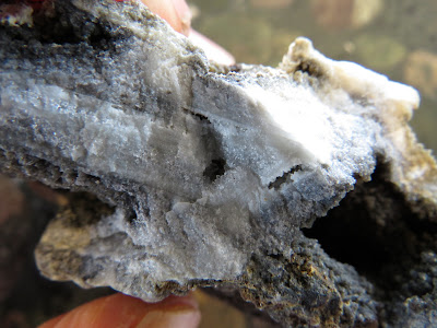
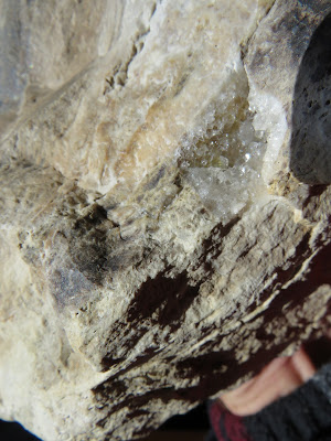
One of the highest points on the peninsula is Blackjack's Hill, which looks out towards the Mercury Islands, and to Opito Point at the end of the peninsula. Blackjack's Hill is the site of a long extinct geothermal field with signs of well preserved quartz and geothermal deposits to be found around the tracks. The details below show example of quartz-based rocks and minerals that can be found inland, and also on beaches and in rivers in the area.
Otama Dunes and Wetland.
Otama Beach forms part of the north-facing coast of the Kuaotunu Peninsula, and is significant as one of the most undisturbed beaches and associated sand-dune formations in the Coromandel. The distinctive white sands are high in quartz and silica, while active dune formations with a back-dune wetland annd associated ecology are increasingly rare. Nearby Sarah's Gully is the site of one of the earliest sites of Māori settlement in the area, with archaeological evidence in the area showing the eastern coast of the Coromandel was a thriving area of settlement up until the arrival of the first Europeans.
 |
| Source: Davidson (2018). In search of the North Island Archaic: Archaeological excavations at Sarah’s Gully, Coromandel Peninsula, New Zealand, from 1956 to 1960. Tuhinga 29: 90–164 |
In more recent times, this area has become the focus of a significant restoration project by the Otama Reserves Group.
 |
| Above and below: Distinctive dunes are formed by pale coloured quartz-rich sands, formed by the weathering of silica-rich volcanic materials. Source: Gravis (2020). |
 |
| Above and below: The dunes harbour a diversity of rare and unusual vegetation adapted to life in this sandy and harsh coastal environment. Source: Chris Twemlow - Otama.org.nz (2020) |
 |
| Trees surrounding the estuary behind the dunes provide a haven for nesting shags Source: Gravis (2020). |
New Chums Beach.
Wainuiototo, more commonly known by the name New Chum Beach, is justifiably well known for its unspoilt sands and specatcular coastal outlook. Less well-known are spectacular outcrops of volcanic breccia originating from one of the main eruption centres in this area. Brightly coloured scoria and andesitic pebbles and boulders are preserved in a matrix of ash and tephra, with weathering leaving fresh surfaces well exposed.
 |
| Above: Coastal erosion processes continuously expose fresh surfaces, allowing a view into the volcanic features formed during unfolding eruptive processes. Source: Gravis (2020). |
 |
| Above: Erosion exposes the inner workings of a volcano, with a dyke and layers of ash and volcanic debris visible here. Source:Karoly Nemeth (2020). |
Coromandel Granite.
This distinctive igneous rock is well known as "Coromandel Granite", though strictly speaking it is more correctly defined as a tonolite due to its mineral composition. Granitic type igneous rocks form when magma does not erupt to the surface as lava, but slowly cools underground. This slow cooling, which may take thousands to millions of years, allow the large crystals to form which are so clearly visible in these types of rocks. Over time uplift and surface erosion expose the granite body (or pluton) where we find it at the present-day surface.
The Coromandel Granite is significant because it is a very rare outcrop of plutonic rock in the North Island, with most granites found at the surface in New Zealand in the South Island. For a time it was quarried and used as a building stone, including in the Old Parliament buildings in Wellington.
This fascinating area tells a story of volcanic processes taking place deep underground millions of years ago.It is also significant as a site of a considerable stone extraction industry, utilising a locally unique stone resource with relative ease of access and proximity to local shipping routes. However, over time the extraction and supply became uneconomic, especially in the context of an increasingly globalised stone supply industry.
 |
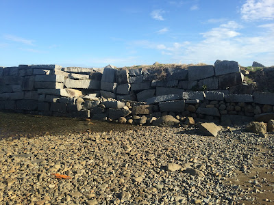
| Above: This zoomed detail from the image above clearly shows the stone wharf, and nearby houses for quarry workers. To the left can be seen a distinctive tidal shore platform formed by the hard erosion resistant igneous rock. Source: retrolens.nz (2020). |
 | |
| Above: The structure of the wharf formed by blocks of this very hard igneous rock remain clearly visible here. Source: Gravis (2020). |
 |
| Above: Parliament buildings in Wellington, showing steps and the bases of columns made of Coromandel Granite and facings and colums made of Tākaka Marble. Source: Te Ara - The Encycopedia of New Zealand (2020) Photograph by Alastair McLean. |
Acknowledgements
 |
| Above: Follow this link to a full copy of The Ghosts of Old Volcanoes, A geoheritage trail concept for Eastern Coromandel Peninsula, New Zealand. |
 |
| "Out of the Ocean, Into the Fire" by Bruce Hayward provides a good overview of the geological history of the Coromandel in the context of the upper North Island. |


Great read, thanks Ilmars
ReplyDelete